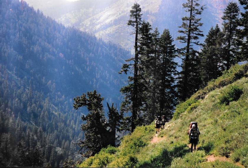
” You’re not lost if you’re happy where you are,” is a quote I altered and sometimes used. And I repeated it in my mind several times as we kept walking into the thick fog, headed toward the summit of Chiefs Head in Colorado’s Rocky Mountain National Park. I was bringing up the rear of a group of ten teenage backpackers and was typically confident about wherever Mike was leading us. But not in this instance. His assistant mountain guide, Dennis, was with me at the back of the line and kept muttering about how we were going up the wrong mountain.
The visibility was like pea soup out in that high mountain world. There were times when I couldn’t even see the front of the group. Enormous rock slabs and huge boulders looked downright puny as we kept weaving our way between one after another of them. I knew there was a magnificent alpine world of massive peaks, summer snowfields, jagged cliffs, and remote valleys surrounding us. But, for the moment, they were out of sight and out of mind.
I wouldn’t have thought about much besides how fantastic the place we were walking in was, except for Dennis’s conjectures. Even with the fog, I could see the thick clouds magically rising, falling, and then re-creating our world, and I was eager to see what each new moment had in store.
The situation probably should’ve been more disconcerting. But as I looked at the people walking ahead, I realized how well prepared they were for the conditions, no matter what happened. Everyone had solid rain gear, fleece for warmth, and warm sleeping bags. And as a group, we had sturdy tents that didn’t leak, enough food for days, and plenty of fuel for our stoves. Finally, and perhaps most importantly, we had plenty of experience. It was then that I realized that even if we were headed up toward the wrong summit, we’d be okay. We’d be fine because we were prepared, both gear-wise and mentally, for whatever might occur. At that point, I quit worrying about where we were or weren’t going. Instead, I focused on pondering the strangeness of the surroundings and relished the moment’s mystery.
Six months earlier, while sitting at my desk, I hadn’t pictured our trek along the Continental Divide in this way. While planning the trip, Mike told me it was realistically doable for a group of teenagers. And he said the route would take us through spectacular, remote high country and to the summits of several peaks, though he didn’t mince words about the trek being a bit of a grind. He knew what real outdoor adventure was and said it would undoubtedly be just that. But it wasn’t until we walked into the cloud that morning that the “real” adventure part began.
My initial thought was that the conditions were simply miserable. I couldn’t fully see more than four people in front of me, much less any distant or nearby mountains. The wet tundra had entirely soaked my boots. A persistent mist continually peppered my face, and my pack grew heavier with rainwater by the minute. To top the misery off, whenever we stopped, and I was inclined to sit down and rest, I was stymied in my thoughts to do so by the wet rocks. Putting on rain gear was out of the question since the air was too warm for that. I knew where the combination of physical exertion and non-breathable rain pants would take me, and I didn’t want to go there.
As I walked through the cloud, my prevailing thought was how it was an uncomfortable, albeit intriguing, day to be out backpacking. But the realization that we needed to get to the mythical Point B on the map had me in “suck it up” mode. Then, just as I was thinking about how things couldn’t get much more unpleasant, we stopped, and Mike huddled us all up where we could see each other. We were standing around a pile of rocks, and I could see we were on a high point of some sort. With complete confidence, he announced we’d made it to the summit of Chiefs Head. As he made his announcement, he reached into the pile, pulled out the summit register tube, opened it, and took out the signature tablet. Then, as we all congratulated each other on our efforts, he began to read the inscription dramatically, which declared that we were indeed on the summit of Mt. Alice.
“Wait,” I thought, “that’s not right.”
There was instantaneous confusion as he uttered the words. But he pointed out almost seamlessly that someone had switched the summit registers, probably as a prank. The congratulations abruptly stopped when he made the official announcement. But the resulting confusion was soon averted by his pronouncement of what probably happened. I felt the relief in the air as everyone realized we hadn’t been walking uphill for hours in the fog to little avail. So, to prove his point about the trickery, he began walking down the other side of the mountain into the fog while describing how the Chiefs Head ridge continued southward, was mellow, and easily walkable. He soon disappeared into the cloud, all the while continuing to talk.
It became eerily quiet as his voice faded away. Everyone stared into the blank spot where we’d last seen him. After a few minutes of looking at the fog and listening to the silence, I became concerned. But then he suddenly reappeared and announced that the mighty East Face of Mt. Alice was less than 100 feet to our side, and we actually were on the wrong peak.
My first instinct was to take a deep breath as I pondered the situation. But then, both Mike and Dennis each told us we’d simply follow an alternative walkable ridge that would eventually take us to our destination. And so, we all relaxed as we realized we weren’t going to have to backtrack. I knew we had everything needed to comfortably and safely get where we were going. It was further affirmation of what I’d realized earlier that day about being lost. And so, we regrouped and headed into the fog and an exciting, mysterious world.
Sixteen empty soda bottles sat on the counter in the Cerro Colorado store for two days before the shopkeeper finally moved them down with the other empties. They’d been a good conversation piece sitting there on the counter. But when he found a spider in one, he put them into some empty slots in the Fanta case on the floor. Later that day, while tidying things up, he dragged the box of empties out from behind the Sabritas rack so they’d be noticeable. That way, they could continue being the talk of the town. But, after thinking it through, he realized that if he did so, they’d get in the way and make things look disorganized. And so, once the case was full, he just stuck it in the back room with the others.
Deep in the heart of Wyoming’s Wind River Range, there’s a place that we call Golden Lake. No marked or named trails go there, and if you look at a map or search a guidebook for information about it, you’ll find nothing. But, while there is a lake, it has another name. It sits in a glacial cirque, along with two other small lakes, at the head of an obscure drainage that descends from the Continental Divide to the North Fork of the Popo Agie River. The main lake of the three is full of Golden Trout. Thus, the name.
It wasn’t the easy way out of the predicament. But we chose the more physically painful of the two options, climbed up the steep ridge, then over the saddle that led us out of Paradise Park and down into Hell Canyon.
What follows is the story of how the situation unfolded:
The group went to work busily, setting up tents and preparing our backcountry campsite. It was the theoretical end to a long day of backpacking. We were in the Colorado mountains at a remote location in Rocky Mountain National Park called Paradise Park. And before organizing my gear, I did one of the more essential things outdoor adventure guides should do before leading a group into the wilds. I took the guidebook out of my backpack and read about where we were setting up camp. There was no ambiguity in what I read: “There is no overnight camping allowed anywhere in Paradise Park.” Initially, I might have been reading it wrong, so I re-read it. But the second time around, the words were the same. And I realized that if we stayed, we’d not only be violating federal regulations but also likely be doing something environmentally detrimental. And so, I concluded we needed to move.
The teenagers were methodically getting things ready for supper and the night ahead. I couldn’t help but note how physically wasted they all looked as I yelled, “Oh, shit!” At that point, it no longer mattered that we’d backpacked and bushwhacked for 6 hours, our legs were tired, or we thought we were at our destination- because we needed to move our campsite.
Thankfully, we were only about a half-mile away from the southwestern boundary of the Park. On the topo map, I noted a pass on the ridge to our south, which we could cross to exit the National Park and enter the Indian Peaks Wilderness. More specifically, it would take us to the high mountain backcountry basin known as Hell Canyon. The place’s name didn’t sound particularly inviting. But I was pleased to know there was somewhere nearby we could move to where we could camp without causing physical harm to the area.
My scream caused the brakes to be applied to the campsite set-up operation. So, for the moment, there was a pause in the activity as everyone waited to find out what the commotion was about.
After my initial attention-getting blurt out, I said calmly, “We can’t stay here; there’s no camping allowed.”
I recognized that I should’ve figured out the camping situation before traipsing 15 miles into the backcountry with them. But I knew that worrying about it wouldn’t help rectify a situation that needed rectifying. It was 5:00 in the afternoon, and I figured we had about three more hours of daylight left and would need every bit of it to reach another suitable spot to set up tents and have a pleasant supper. And so, I accepted the reality that we had to get moving and that it needed to happen sooner rather than later.
Looking around at the various group members, I could see they were, in turn, looking out at our nearby surroundings. It was evident they were trying to figure out where the actual Paradise Park boundary lay and, thus, where we needed to go. I began explaining the situation and realized that most of the teenagers were mentally preparing themselves for something much easier than what needed to happen. Just the irritation of having to pack their stuff back up and move a few hundred yards before eating supper would be plenty painful. But little did they know…
After a few long moments of looking around, one of the group members said, “Where to?”
I didn’t say anything initially because I didn’t have the heart. But I did look up at the not-so-distant pass. Everyone turned and looked up to where my eyes were pointing, and there was a profound moment of silence as it all began to soak in.
And so, I verbalized the new plan. While pointing up toward the pass, I said, “The boundary between the National Park and the Indian Peaks Wilderness is along that ridge. There’s a pass up there between those two peaks. If we climb up and cross it, according to the topo, we can just walk down from there into a place called Hell Canyon. It looks like there are all kinds of climbing down there, some lakes, and a trail that’ll take us back pretty close to where we ultimately need to get to at the end of the trip. We ought to be able to get up and over the pass and set up camp before dark if we get moving now. So, let’s go!”
The silence continued after I finished speaking. I wanted to think it was because everyone was busy developing thoughtful, efficient personal move plans. But more than likely, it was because they were attempting to process their disbelief. I don’t think anyone was all that interested in the fishing, climbing, or backcountry options in Hell Canyon. But I do believe that some of them thought it was a cruel joke.
After a few minutes, everyone came to grips with the reality of the moment and just began re-packing. I felt terrible about the situation and was also tired. But once we were packed up and moving, I felt only their positive energy, not the lethargy and fatigue I expected. I watched as 12 ordinary people headed out toward an unknown destination, their energy coming from somewhere I couldn’t see. In an instant, each became a sort of unassuming superhuman.
With the sun creeping down in the western sky, we crossed over the pass and began the descent into a place we’d known nothing about a few hours before. Mount Hiamovi dominated the eastern sky, and Upper Stone Lake shone like a mirror to our south and a thousand feet below. A pleasant tundra-covered slope cut through massive rock outcroppings to either side. It provided straightforward access to our new world. Before we knew it, we walked out on a boulder and saw only clear sailing ahead as we transitioned from going up to going down.
It turns out that the place we went is known as one of the wildest and most spectacular places in North America. Few people get there because it’s so remote and hard to reach. I witnessed an intriguing power and wild spirit in the place and the people during that late afternoon. It suddenly became clear to me just how remarkable and capable humanity and nature are.
And to think—it wasn’t even somewhere any of us had planned to go that day.
The solution wasn’t jumping out at her. Nothing about the situation made any sense. Why had he said that? His conclusion wasn’t logical. Her mind worked in overdrive to come up with an answer to the problem, although a part of her feared there might not be one. Maybe I should….. But her chain of thought was broken by the reality of the moment. She looked down at the ground, some 30′ below, and her focus reverted to the rock. The climb was rated 5.12 and named “Second Thoughts,” of all things. And from that point forward, the thing that mattered to her most was the few square feet of rock surrounding her.
The countryside opened up as the Silver Trail left the Valley of the Churches. Earlier that day, our group of seven backpackers passed a young Tarahumara man (the indigenous people of Mexico’s Copper Canyon), and I asked him about Nacho Kino. Nacho was an elderly Tarahumara man I’d met while mapping the Silver Trail a few years before, who seemed well regarded in that area.
I was in Mexico’s Copper Canyon leading a group of “Chavochi”adventure travelers. “Chavochi” is basically the Tarahumara word for Gringo, non-indigenous, devil people. Various things happened while we were down there in Batopilas Canyon and the town of Batopilas, which may or may not be related. I think they are.
The various names that are attached to places are intriguing. Some are obvious since they either reflect a physical characteristic or commemorate an individual of importance. But, others not quite so. Many place names tell a story in a few short words—some less straightforward than others, but each worthy of knowing. Here’s a few such stories that I’ve heard. Listen, and maybe you will, too………………..
Winter camping and cross country skiing in Glacier National Park.
Winter-like Camping
It was a bit of naivety that got the three of us there- that and my Ford pickup. A thousand or so miles of driving took us from Texas to Montana’s Glacier National Park, where we planned to live out our dreams of winter camping and cross-country skiing. We had the place pretty much to ourselves when we arrived, probably because it was January. We were alone when we pulled in, except for the two park rangers at the Polebridge Ranger Station (where we entered the park) and the plethora of wildlife still out and about.
The group included me, David Barrow (from the Acapulco trip), and Jeff Isom (owner of the Skeeter Fogger and veteran of the ’78 Flood at Camp Stewart). We selected the destination at least partly because of Texas friends who lived nearby. We figured we could combine some winter outdoor adventure with a visit. It was our idea of a good, multi-faceted “ski trip.”
We arrived at our campsite in the full, mid-afternoon, and paltry winter sunshine of the northern Rockies. Thankfully, the road to the campground and Bowman Lake was snowplowed for a short distance from the entrance station, allowing us to drive right up to our site in the otherwise empty campground. The foot of snow and vacant camping spaces, combined with the strange lighting and magnificent mountain views, created a feeling of being in the backcountry.
Since most of the park is closed in the winter, I’m not quite sure how we got our camping permit in the first place. It may have been that none of the park employees had ever considered the possibility of having campers at that time of the year. So, when I got the actual permit, I felt we were doing something that was allowed, only because no one had thought there was a need to make it otherwise.
The temperature was still well up into the teens as we brushed the snow off the picnic table and set things up for cooking supper. By the time it got dark around 4:30, we were finishing our evening meal, and by 5:00, we were snug in the relative warmth of our sleeping bags inside our tent. We hadn’t slept much on the drive up from Texas. So, we were excited by the prospect of the uninterrupted 14-hour sleep that awaited.
I first awoke around midnight, ready to start the day, but realized it was a bit early and slipped back into a semi-conscious trance. But by 8:00 a.m., it was starting to get light, and I was intent on getting up and moving. So, I climbed out of the tent and into a breathtakingly fresh morning. One of the positive aspects of the cold temperature was that the snow on the picnic table and elsewhere didn’t melt quickly, keeping things dry. We knew ice and snow were necessary parts of winter camping and winter sports. And we’d read a good deal about how important it was to keep it out of your clothes, which could lead to wetness and ultimately hypothermia. So, we decided to avoid that situation entirely by not messing with the fluffy stuff unduly.
Barrow and Jeff soon joined me outside in the morning air. We didn’t bother with a campfire, which prevented us from warming up but ultimately sped up our breakfast preparation. We were eager to get ourselves geared up and ready for an exciting, full day of cross-country skiing, which we assumed would be both fun and warming. None of us knew much about skiing. However, Jeff and Barrow had both been downhill skiing before. As for me, I’d only spent a couple of hours cross-country skiing one time in Wisconsin. Suffice it to say, we were novices at the sport. But each of us had read about how to do it, so at least we could talk about it. It sounded fun, and after our research, we felt well prepared and speculated positively about “how hard could it be?”
The same road we took into the campground continued further into the park. Since it was unplowed past the campground, it made for an exceptional ski route. We’d purchased and brought along brand-new waxless cross-country track skis. We geared up near the picnic table and, even without instructions, eventually got them attached to our feet correctly. And we did so, even without heat other than the fragments of muted sunlight beaming through the tree limbs. We weren’t about to let finger numbness or cold toes get in the way of our plan. We were having a good time winter camping in the wilds of Montana, and were about to go cross-country skiing, and weren’t going to let anything get in the way of our fun. As far as we were concerned, the pain we were experiencing with our hands and toes was just a “part of it.”
I was almost amazed and somewhat surprised when I looked down at my feet and saw the skis attached. At that moment, I concluded I’d fulfilled my vision of camping in the snow and cross-country skiing. It was January in the mountains, and we were about to ski into the wilderness. It didn’t seem to matter to any of us that the organized part of our winter camping/ski trip plans, such as they were, ended there. Since that trip, I’ve often wondered if we’d realized at the time what we didn’t know, would we have done it anyway?
Once outfitted and ready, we stood motionless in the snow for a moment, unsure what to do next, and that made us realize just how cold it was. That fact, combined with our excitement to see where the road/trail went, led us to the abrupt conclusion that it was time to get moving. Conveniently, ski tracks led up the road almost right from where we stood, and within only minutes, we were on our way.
The first half mile was almost flat as the road meandered into and through an ever-thickening forest. The low, slightly uphill angle of the road/ski slope allowed us to cover a significant distance with little effort. The forest was thick on either side but soon opened up, framing a distant, particularly magnificent peak. The only noise we heard was the swooshing of our skis as their sliding surfaces bit into the track, allowing us to continue moving forward. It was just as described in the magazines.
Those first few minutes were subtly profound for me. The winter light, the quiet of the snow, the lack of wind, the low temperature, and the absence of other people muted the surrounding world. And at the same time, I felt a strong sense of enormity, complexity, and sharpness as I found myself for the first time amid winter wildness.
It occurred to me that some anonymous, long-gone skiers had left the tracks we were following. And that with the arrival of spring, the lines in the snow would inevitably melt away. At the same time, I concluded that trails are permanent, and their existence doesn’t depend on the weather or time of year.
As we skied up the road, I had the continual sense that eyes were staring at us, invisibly from somewhere far off and back in the trees. Clouds soon began rolling in, thickening the sky. The air warmed, but not in a thawing way. A hawk screeched in the distance, and we rounded a corner and witnessed a new vista of big and magnificent peaks filling in the forest/picture frame in front of us.
After 30 minutes or so of shushing along, we arrived at the top of a gradual hill and decided to stop, turn, and have some downhill fun. We’d put in our work while kicking and only slightly gliding our way up, and decided it was time for some payback. And payback is what we got, though it wasn’t the fun kind we’d envisioned. We stopped and turned to retrace and slide down 100 yards of our path, which essentially made it “a downhill.” Slot cars come to mind as I reflect on that first descent. Thank goodness the trail turned and flattened out when it did, or we would have had to intentionally crash before reaching terminal velocity, because we certainly had no control over the skis. I don’t recall knowing anything about managing downhill speed, and apparently just reckoned that part would somehow come naturally.
Those first crashes dashed any hopes we had of staying dry. Initially, we were relieved to be in one piece after each downhill run. Up to that point, we assumed that the snow that entered every crevice of our tightly bundled bodies was of no consequence. So, at first, we just brushed it away. But eventually, the bits trapped within our clothes began to melt. And after only a couple of crashes, I was starting to get noticeably damp and chilled. It was just like the books had warned. When I combined that with the physical pounding I was taking, I decided that falling and the kind of downhill we were experiencing was not all that fun.
My two companions came to the same conclusion, and we decided the tracks were actually creating the problem. So, we determined we needed to find a downhill slope devoid of any. At that point, we proceeded up the road toward Bowman Lake, equipped with the mission of looking for a better place to slide out of control and crash.
We kicked and glided for another quarter of a mile, looking to either side for an untrodden, open, and suitably sloped area for more downhill. Instinctively, a suitable landing area had also become a prerequisite.
Suddenly, the narrow, tree-shrouded roadway we were skiing up opened into a vast meadow. And what appeared to be an almost-perfect downhill ski embankment sat close to the road, and we could easily reach it. At first sight, any apprehensions about finding the right spot evaporated. We knew we’d found it and didn’t hesitate, immediately working our way to its base.
The hill was about 20 feet tall with a moderate grade and a large and open flat area, or “run out,” at the bottom. The forest stopped well back from the top, leaving most of the big trees standing away from it. There didn’t appear to be any visible obstructions along most of its slope. The open space offered plenty of room to turn and maneuver, or whatever it was people did, as they slid blissfully downhill. It seemed to be just the kind of spot we were looking for.
We slowly sidestepped our way up to the top. Once there, the entire meadow came into view, and we saw a massive herd of elk almost overwhelming its northern edge, only 500 yards away. Steam rose in sporadic whiffs around the animals, rising from elk bodies warmed by either playful bantering or massive exhales. Thin clouds took over the sky, and snow flurries fell harmlessly almost straight down.
I marveled at how the scene kept becoming even more perfect. First, the timing had come together so that the three of us could be there in the first place. Then, Jeff had miraculously recovered from his flu, or whatever it was he had on the way up. And the highway from Texas had been clear, and the driving fast and easy. Also, we had the campground all to ourselves and had learned a lot about winter camping in only our first night out. And finally, we were about to solve the last piece of the cross-country skiing puzzle and do some real downhill. To top it all off, it was lightly and peacefully snowing, a herd of elk was meandering around in the near distance, and we were warmish. It was all going so well that I began contemplating writing a magazine story about the whole experience—a sort of “how-to” about winter camping and skiing.
Since I had the least idea about skiing down the hill, I got to go first. Jeff had time to spare until it was his turn. Because he was intrigued by the sight of the elk, he decided to take the opportunity to ski up near them and get a closer look. As I was preparing for my ski run, he disappeared into the thickness of the forest.
I was a little surprised by just how long and steep the slope appeared from my vantage point on its upper edge. I looked at the bottom again and felt better about it, noting the wide-open, long “slowing down and stopping area” at the bottom. And so, with no further thoughts, I pushed off. I was amazed by how quickly I gained momentum as the slide got underway. There was no time to consider turning or controlling my speed. Instead, I crouched into a full downhill, Katie-bar-the-door, tucked position with skis pointed straight toward the bottom. The 20′ downhill was over in seconds as the run-out thankfully took over and brought me to a stop. Somehow, I hadn’t fallen. And, as a bonus, I’d learned that there was no need to worry about anything regarding going downhill on skis other than the need to keep them pointed downhill.
Once I came to my stop, I turned and looked back up to the top, where Barrow was getting into position for his run.
“It’s perfect,” I yelled.
And then, in another instant, he went over the edge, taking a similar line to mine and using the same technique. He, too, made it to the bottom unscathed. Success and more information for my story, I concluded. I reckoned I could add a box or something about downhill cross-country ski technique. I recognized I needed to take particular note of the details of what we were doing during our subsequent few runs if I was going to come off as a true expert.
Once we were at the bottom, we congratulated each other on making it down successfully and on how awesome it was. Immediately, we began heading back up for another go. It took a few minutes to get up there, but there was no hesitation as we reached the top and immediately turned and headed back down. The second run was even better than the first, since by then we knew what to expect and wasted no time worrying about technique uncertainties.
Then, Jeff appeared just as we began side-stepping back up for our third descent.
We both yelled up to him, “The snow’s good. Just point your skis down, and you’ll come to a stop at the bottom. You don’t have to do anything.”
He didn’t need our encouragement and skied up to the edge and went over without hesitation. From our new vantage point to the side, we were startled to see how fast he got going as he zoomed past. Quickly, he reached the bottom still upright, and as expected, slowed to a stop.
“Wow, that was good,” he said.
And then Barrow asked, “Did you get up close to the elk?”
“Not really,” he answered. “But I did ski up on some wolves, I think.”
“Coyotes, probably coyotes,” I was relatively sure in my response.
“No, they were way too big for that,” he confidently responded.
So, we left the wolf or coyote mystery unsolved and ended up playing on the hill until we just got too tired to make another climb back to the top. And I collected all the info I needed for my article. So, in the early afternoon, we headed back to camp, skiing and crashing our way back down way faster than we’d gone up. After our day of skiing, we spent one more night camping. At that point, it became time for the second part of the trip. Phase 2 included staying in a warm house and the opportunity to perfect my cross-country downhill Telemark turns at the local downhill ski area.
All in all, it was an almost perfect trip. During those few days of cold and snow, I had my first taste of actual winter camping, learned some of the nuances of downhill skiing, and might have been close to wolves for the first time. On the drive back to Texas, I tried to ponder the cold, pain, and numbness of the previous days. I wanted to be glad and content to be in my pickup truck with a good heater and on a well-paved road. But each time I did, I thought back to one of our painful moments when I saw ski tracks heading quietly into the forest. In that thought, there were rugged and wild snow-covered peaks in every direction, and I could hear wolves howling in the distance. It was then that I concluded that sometimes the rewards are indeed worth a little pain.
Practicing ice climbing near the top of Black Powder Pass
For whatever reason, my wife, Lori, and I ended up in Potosi, Bolivia, on that particular part of our vacation. After considering various things to do around the city, we ended up selecting the “mine tour” option. The city is over 200 miles south of the capital city of La Paz. At 13,400 feet of elevation, it’s one of the world’s highest cities. And, as we came to find out, it’s dominated by Cerro Rico, a big mountain which has been mined regularly for silver ever since the days when the Spaniards were the rulers.


You must be logged in to post a comment.